Spatial Databases
A spatial database is a system designed to store and query data representing objects defined in a geometric space, such as locations, shapes, and geographical features.
These databases are essential for applications involving geospatial data, including Geographic Information Systems (GIS), urban planning, GPS navigation, environmental monitoring, and natural resource management.
Three key aspects differentiate spatial databases in terms of flexibility, performance, and analytical capabilities:
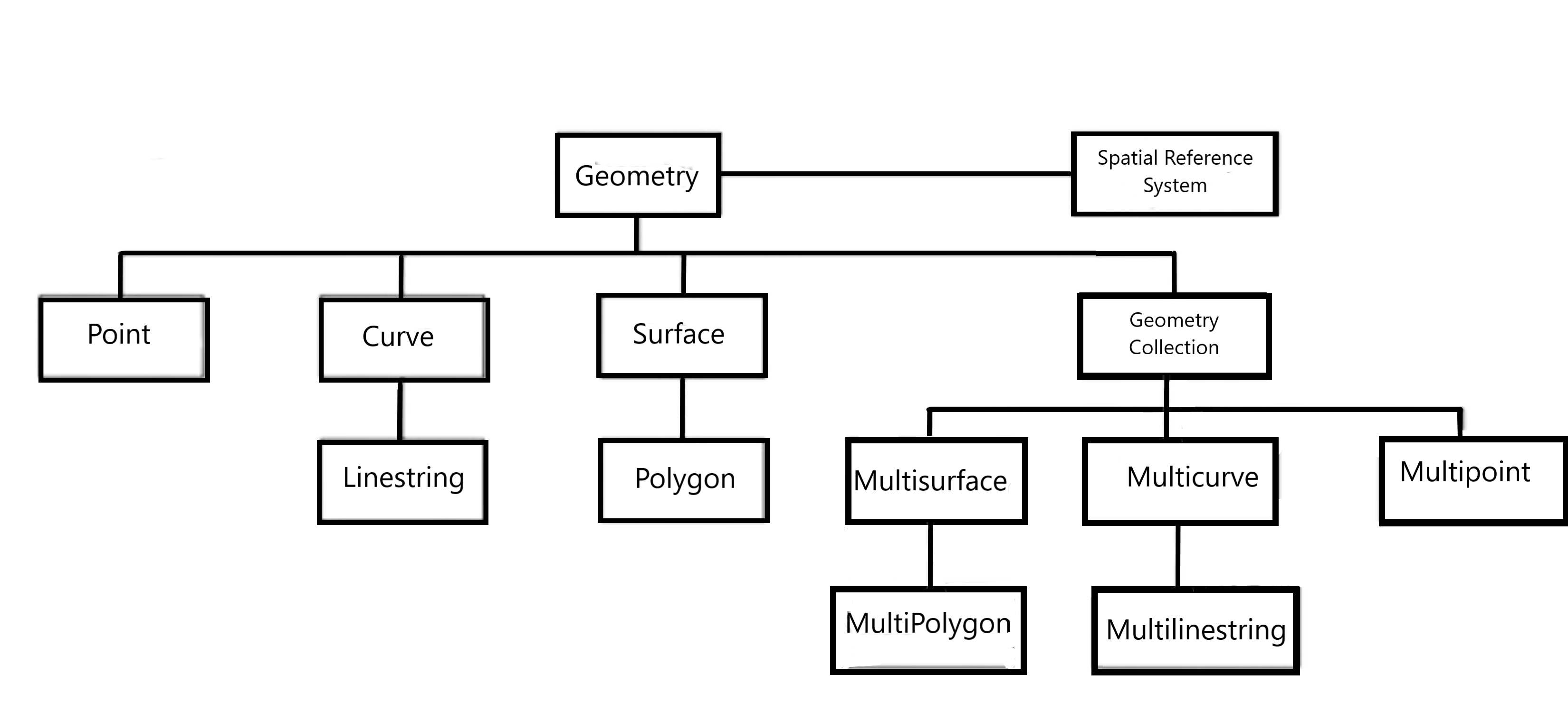
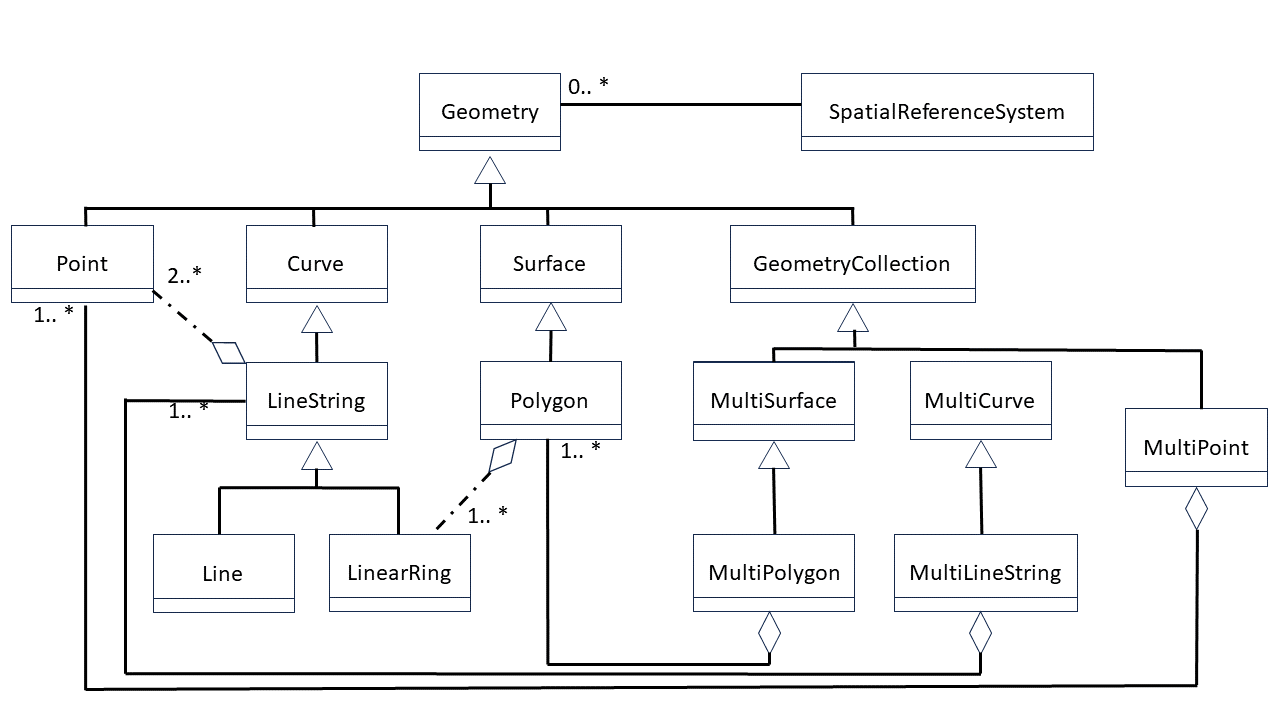
- Spatial data types: Most spatial databases support basic vector data types such as points, lines, polygons, and symbols. Some go further by supporting complex spatial objects like raster images and 3D scenes. Many implement standards defined by the OGC - Open Geospatial Consortium.
- Spatial indexing: Spatial indexes are critical for query performance and vary among implementations. These multidimensional indexes enable efficient spatial operations such as containment, intersection, and proximity queries.
- Spatial functions: These are functions available in SQL that allow querying spatial properties and relationships—for example, determining if one geometry intersects, contains, or is within another.
spatial databases are not limited to geographic applications. They can be used in applications beyond the geographical scope, such as human body anatomy, large-scale integrated circuits, molecular structures, electromagnetic fields, and others.
Spatial Databases Characteristics
While traditional databases support standard data types like numbers, strings, and dates, spatial databases introduce specialized data types to represent geographic and spatial features. They are typically organized into a type hierarchy, where each subtype inherits attributes and behaviors from its supertype, allowing modular and extensible modeling of spatial information.
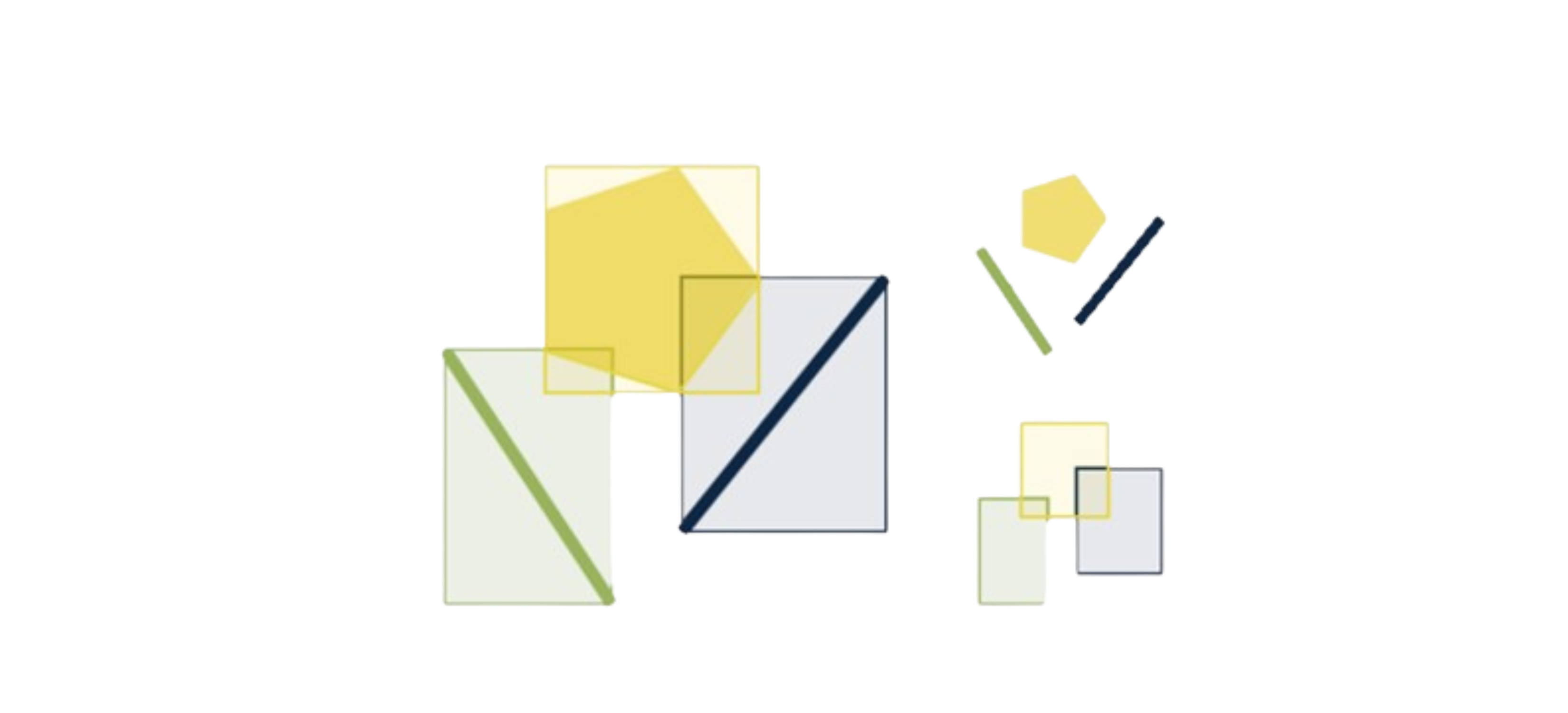
Another difference is the ability to quickly and randomly access a subset of data. In traditional databases, this is typically achieved using B-Tree indexes. In contrast, spatial databases use spatial indexes to answer questions such as “Which objects are within this specific bounding box?”. Common implementations include R-Trees, Quadtrees, grid-based indexes, and GeoHash.
Spatial databases provide a set of functions to analyze geometric components, determine spatial relationships, and manipulate geometries - including their conversion, management, retrieval, comparison, and the generation of new geometries.
Spatial Reference Systems
A Spatial Reference System is a coordinate framework used to describe the position and orientation of objects in space. It provides a basis for locating points, determining directions, and measuring distances in three-dimensional space. There are different types of spatial reference systems, such as Cartesian, spherical, and celestial systems - each with its own coordinate structure and measurement methods.
Geographic Information Systems (GIS) and spatial databases use Spatial Reference System Identifiers (SRIDs) to ensure that geographic data is correctly interpreted relative to the appropriate coordinate system. An SRID is a numeric code that uniquely identifies a specific spatial reference system. Examples include WGS84 (World Geodetic System 1984) and UTM (Universal Transverse Mercator).
SRIDs allow software systems to correctly process and interpret spatial data, ensuring accuracy and consistency in geospatial analysis and visualization.
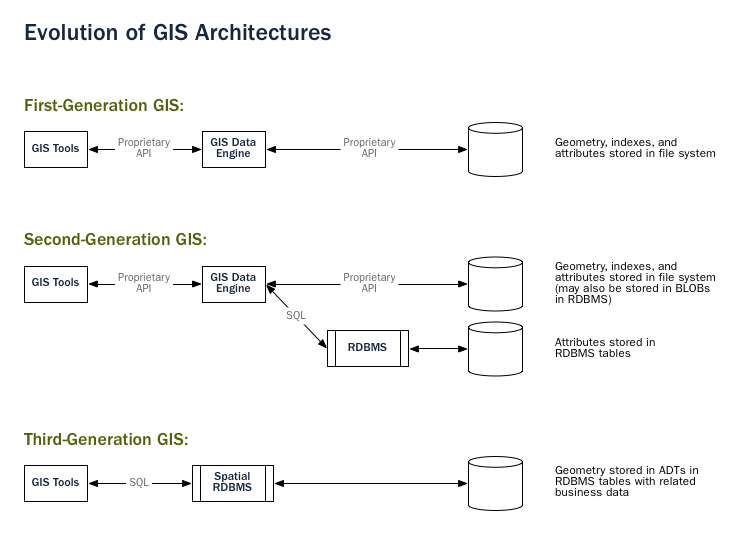
Geospatial Information Systems Architecture
The architecture of Geospatial Information Systems has evolved from data stored in flat files to full integration with object-relational databases. This evolution has enabled more secure, faster, and efficient systems for working with geospatial information.
PostGIS
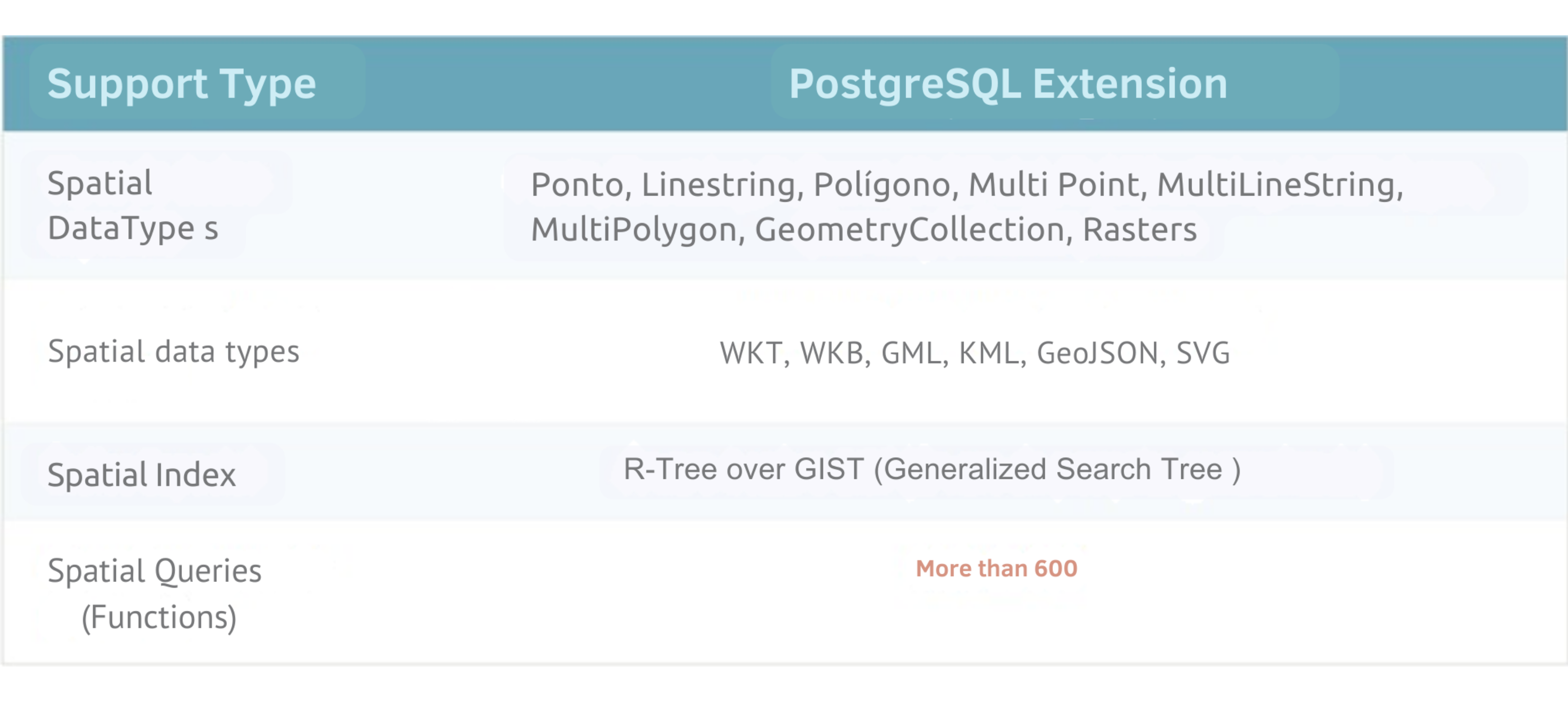
PostGIS is a free and open-source spatial extension for PostgreSQL that enhances its capabilities by enabling the storage, indexing, and querying of spatial data. It transforms PostgreSQL into a full-featured spatial database, allowing the use and management of GIS (Geographic Information Systems) objects. It supports GiST and R-Tree spatial indexes and provides functions for spatial analysis and GIS object processing.
PostGIS adheres to the standards of the OGC - Open Geospatial Consortium and is widely adopted. It enables operations such as distance calculations between GPS coordinates, spatial joins, and other advanced geospatial functions.
Since its first version in May 2001, PostGIS has evolved significantly, adding support for data analysis, integration with external applications like Mapserver and GEOS, and adherence to the OGC's "Simple Features for SQL" specifications.
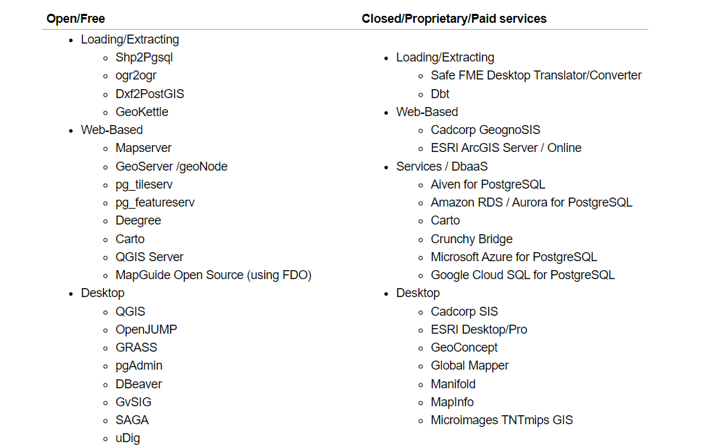
Various organizations and software use PostGIS. Below are some examples:
PostGIS Features
PostGIS extends the features of the PostgreSQL database management system by adding support for storing, indexing, and querying geospatial data:
- Spatial Data Storage: Enables the storage of various types of spatial data, such as points, lines, polygons, and multi-geometries, in both 2D and 3D formats;
- Spatial Indexing: Facilitates fast search and retrieval of spatial data based on location using efficient spatial indexes;
- Spatial Functions: Provides a wide range of functions for spatial analysis, allowing filtering, computation, and geometric operations on spatial data;
- Geometry Processing: Includes tools for processing and manipulating geometries, such as simplification, conversion, and generalization of spatial data;
- Raster Data Support: Supports the storage and processing of raster images and grid data, such as elevation maps and satellite imagery;
- Geocoding and Reverse Geocoding: Offers functions to convert addresses into geographic coordinates and vice versa;
- Integration: Can be integrated with a variety of third-party tools and platforms such as QGIS, GeoServer, MapServer, ArcGIS, and Tableau for spatial data analysis and visualization.
PostGIS is a powerful and flexible tool for managing spatial data in a relational database environment, offering comprehensive support for a wide range of geospatial applications.
- Source: https://www.postgis.net