PostGIS
Synopsis
+geometry +ST_VoronoiLines( geometry geom , float8
tolerance = 0.0 , geometry extend_to = NULL );
Description
Computes a two-dimensional
Voronoi diagram from the
vertices of the supplied geometry and returns the boundaries between
cells in the diagram as a MultiLineString. Returns null if input
geometry is null. Returns an empty geometry collection if the input
geometry contains only one vertex. Returns an empty geometry collection
if the extend_to envelope has zero area.
Optional parameters:
-
tolerance: The distance within which vertices will be considered equivalent. Robustness of the algorithm can be improved by supplying a nonzero tolerance distance. (default = 0.0) -
extend_to: If present, the diagram is extended to cover the envelope of the supplied geometry, unless smaller than the default envelope (default = NULL, default envelope is the bounding box of the input expanded by about 50%).
Performed by the GEOS module.
Availability: 2.3.0
Examples

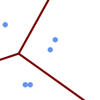
Voronoi diagram lines, with tolerance of 30 units
SELECT ST_VoronoiLines(
            'MULTIPOINT (50 30, 60 30, 100 100,10 150, 110 120)'::geometry,
            30) AS geom;
ST_AsText output
MULTILINESTRING((135.555555555556 270,36.8181818181818 92.2727272727273),(36.8181818181818 92.2727272727273,-110 43.3333333333333),(230 -45.7142857142858,36.8181818181818 92.2727272727273))