PostGIS
Synopsis
+geometry +ST_ShortestLine(+`geometry `+geom1, geometry
geom2`)`;
+geography +ST_ShortestLine(+`geography `+geom1, geography
geom2, boolean use_spheroid = true`)`;
Description
Returns the 2-dimensional shortest line between two geometries. The line
returned starts in geom1 and ends in geom2. If geom1 and
geom2 intersect the result is a line with start and end at an
intersection point. The length of the line is the same as
ST_Distance returns for g1 and g2.
Enhanced: 3.4.0 - support for geography.
Availability: 1.5.0
Examples
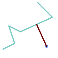
Shortest line between Point and LineString
SELECT ST_AsText(  ST_ShortestLine(
        'POINT (160 40)',
        'LINESTRING (10 30, 50 50, 30 110, 70 90, 180 140, 130 190)')
    ) As sline;
---------------------------------------------------------
 LINESTRING(160 40,125.75342465753425 115.34246575342466)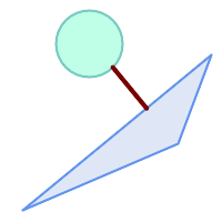
Shortest line between Polygons
SELECT ST_AsText( ST_ShortestLine(
         'POLYGON ((190 150, 20 10, 160 70, 190 150))',
         ST_Buffer('POINT(80 160)', 30)
              ) ) AS llinewkt;
-----------------
LINESTRING(131.59149149528952 101.89887534906197,101.21320343559644 138.78679656440357)