PostGIS
Synopsis
+geometry +ST_LocateBetween(+`geometry `+geom, float8
measure_start, float8 measure_end, float8 offset = 0`)`;
Description
Return a geometry (collection) with the portions of the input measured geometry that match the specified measure range (inclusively).
If the offset is provided, the result is offset to the left or right
of the input line by the specified distance. A positive offset will be
to the left, and a negative one to the right.
Clipping a non-convex POLYGON may produce invalid geometry.
The semantic is specified by the ISO/IEC 13249-3 SQL/MM Spatial standard.
Availability: 1.1.0 by old name ST_Locate_Between_Measures.
Changed: 2.0.0 - in prior versions this used to be called ST_Locate_Between_Measures.
Enhanced: 3.0.0 - added support for POLYGON, TIN, TRIANGLE.
 This
function supports M coordinates.
 This
method implements the SQL/MM specification.
SQL-MM IEC 13249-3: 5.1
Examples
SELECT ST_AsText(
  ST_LocateBetween(
       'MULTILINESTRING M ((1 2 3, 3 4 2, 9 4 3),(1 2 3, 5 4 5))':: geometry,
       1.5, 3 ));
------------------------------------------------------------------------
 GEOMETRYCOLLECTION M (LINESTRING M (1 2 3,3 4 2,9 4 3),POINT M (1 2 3))
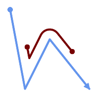
A LineString with the section between measures 2 and 8, offset to the left
SELECT ST_AsText( ST_LocateBetween(
  ST_AddMeasure('LINESTRING (20 180, 50 20, 100 120, 180 20)', 0, 10),
  2, 8,
  20
));
------------------------------------------------------------------------
MULTILINESTRING((54.49835019899045 104.53426957938231,58.70056060327303 82.12248075654186,69.16695286779743 103.05526528559065,82.11145618000168 128.94427190999915,84.24893681714357 132.32493442618113,87.01636951231555 135.21267035596549,90.30307285299679 137.49198684843182,93.97759758337769 139.07172433557758,97.89298381958797 139.8887023914453,101.89263860095893 139.9102465862721,105.81659870902816 139.13549527600819,109.50792827749828 137.5954340631298,112.81899532549731 135.351656550512,115.6173761888606 132.49390095108848,145.31017306064817 95.37790486135405))