PostGIS
Synopsis
+geometry +ST_LineInterpolatePoint(+`geometry
`+a_linestring, float8 a_fraction`)`;
+geography +ST_LineInterpolatePoint(+`geography
`+a_linestring, float8 a_fraction, boolean
use_spheroid = true`)`;
Description
Returns a point interpolated along a line at a fractional location. First argument must be a LINESTRING. Second argument is a float between 0 and 1 representing the fraction of line length where the point is to be located. The Z and M values are interpolated if present.
See ST_LineLocatePoint for computing the line location nearest to a Point.
|
|
Availability: 0.8.2, Z and M supported added in 1.1.1
Changed: 2.1.0. Up to 2.0.x this was called ST_Line_Interpolate_Point.
 This
function supports 3d and will not drop the z-index.
Examples

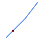
A LineString with the interpolated point at 20% position (0.20)
-- The point 20% along a line

SELECT ST_AsEWKT(  ST_LineInterpolatePoint(
        'LINESTRING(25 50, 100 125, 150 190)',
        0.2 ));
----------------
 POINT(51.5974135047432 76.5974135047432)
The mid-point of a 3D line:
SELECT ST_AsEWKT(  ST_LineInterpolatePoint('
        LINESTRING(1 2 3, 4 5 6, 6 7 8)',
        0.5 ));
--------------------
 POINT(3.5 4.5 5.5)
The closest point on a line to a point:
SELECT ST_AsText( ST_LineInterpolatePoint( line.geom,
                      ST_LineLocatePoint( line.geom, 'POINT(4 3)')))
FROM (SELECT ST_GeomFromText('LINESTRING(1 2, 4 5, 6 7)') As geom) AS line;
------------
 POINT(3 4)