PostGIS
Synopsis
+float +ST_HausdorffDistance(+`geometry `+g1, geometry
g2`)`;
+float +ST_HausdorffDistance(+`geometry `+g1, geometry
g2, float densifyFrac`)`;
Description
Returns the Hausdorff distance between two geometries. The Hausdorff distance is a measure of how similar or dissimilar 2 geometries are.
The function actually computes the "Discrete Hausdorff Distance". This is the Hausdorff distance computed at discrete points on the geometries. The `densifyFrac` parameter can be specified, to provide a more accurate answer by densifying segments before computing the discrete Hausdorff distance. Each segment is split into a number of equal-length subsegments whose fraction of the segment length is closest to the given fraction.
Units are in the units of the spatial reference system of the geometries.
|
Availability: 1.5.0
Examples

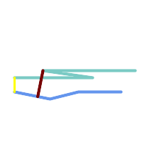
Hausdorff distance (red) and distance (yellow) between two lines
SELECT ST_HausdorffDistance(geomA, geomB),
       ST_Distance(geomA, geomB)
    FROM (SELECT 'LINESTRING (20 70, 70 60, 110 70, 170 70)'::geometry AS geomA,
                 'LINESTRING (20 90, 130 90, 60 100, 190 100)'::geometry AS geomB) AS t;
 st_hausdorffdistance | st_distance
----------------------+-------------
    37.26206567625497 |          20
Example: Hausdorff distance with densification.
SELECT ST_HausdorffDistance(
            'LINESTRING (130 0, 0 0, 0 150)'::geometry,
            'LINESTRING (10 10, 10 150, 130 10)'::geometry,
            0.5);
 ----------------------
          70
Example: For each building, find the parcel that best
represents it. First we require that the parcel intersect with the
building geometry. DISTINCT ON guarantees we get each building
listed only once. ORDER BY .. ST_HausdorffDistance selects the
parcel that is most similar to the building.
SELECT DISTINCT ON (buildings.gid) buildings.gid, parcels.parcel_id
   FROM buildings
       INNER JOIN parcels
       ON ST_Intersects(buildings.geom, parcels.geom)
   ORDER BY buildings.gid, ST_HausdorffDistance(buildings.geom, parcels.geom);