PostGIS
Synopsis
geometry +`*`+ST_GeometricMedian*+ (` geometry `+geom, float8
tolerance = NULL, int max_iter = 10000, boolean
fail_if_not_converged = false`)`;
Description
Computes the approximate geometric median of a MultiPoint geometry using the Weiszfeld algorithm. The geometric median is the point minimizing the sum of distances to the input points. It provides a centrality measure that is less sensitive to outlier points than the centroid (center of mass).
The algorithm iterates until the distance change between successive
iterations is less than the supplied tolerance parameter. If this
condition has not been met after max_iterations iterations, the
function produces an error and exits, unless fail_if_not_converged
is set to false (the default).
If a tolerance argument is not provided, the tolerance value is
calculated based on the extent of the input geometry.
If present, the input point M values are interpreted as their relative weights.
Availability: 2.3.0
Enhanced: 2.5.0 Added support for M as weight of points.
 This
function supports 3d and will not drop the z-index.
This
function supports 3d and will not drop the z-index.
This
function supports M coordinates.
Examples
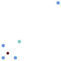
Comparison of the geometric median (red) and centroid (turquoise) of a MultiPoint.
WITH test AS (
SELECT 'MULTIPOINT((10 10), (10 40), (40 10), (190 190))'::geometry geom)
SELECT
  ST_AsText(ST_Centroid(geom)) centroid,
  ST_AsText(ST_GeometricMedian(geom)) median
FROM test;

      centroid      |                 median
--------------------+----------------------------------------
   POINT(62.5 62.5) | POINT(25.01778421249728 25.01778421249728)
(1 row)