PostGIS
Name
ST_ClusterDBSCAN — Window function that returns a cluster id for each input geometry using the DBSCAN algorithm.
Description
A window function that returns a cluster number for each input geometry,
using the 2D Density-based spatial
clustering of applications with noise (DBSCAN) algorithm. Unlike
ST_ClusterKMeans, it does not require the
number of clusters to be specified, but instead uses the desired
distance (eps) and density (minpoints)
parameters to determine each cluster.
An input geometry is added to a cluster if it is either:
Note that border geometries may be within eps distance of core
geometries in more than one cluster. Either assignment would be correct,
so the border geometry will be arbitrarily asssigned to one of the
available clusters. In this situation it is possible for a correct
cluster to be generated with fewer than minpoints geometries. To
ensure deterministic assignment of border geometries (so that repeated
calls to ST_ClusterDBSCAN will produce identical results) use an
ORDER BY clause in the window definition. Ambiguous cluster
assignments may differ from other DBSCAN implementations.
|
Availability: 2.3.0
 This
method supports Circular Strings and Curves.
Examples
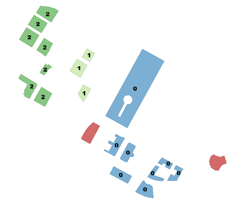
Clustering polygon within 50 meters of each other, and requiring at least 2 polygons per cluster.
Clusters within 50 meters with at least 2 items per cluster. Singletons have NULL for cid |
|
bucket -------------------------------------+-------- Manulife Tower |
0 Park Lane Seaport I |
0 Park Lane Seaport II |
0 Renaissance Boston Waterfront Hotel |
0 Seaport Boston Hotel |
0 Seaport Hotel & World Trade Center |
0 Waterside Place |
0 World Trade Center East |
0 100 Northern Avenue |
1 100 Pier 4 |
1 The Institute of Contemporary Art |
1 101 Seaport |
2 District Hall |
2 One Marina Park Drive |
2 Twenty Two Liberty |
2 Vertex |
2 Vertex |
2 Watermark Seaport |
2 Blue Hills Bank Pavilion |
NULL World Trade Center West |
A example showing combining parcels with the same cluster number into geometry collections.
SELECT cid, ST_Collect(geom) AS cluster_geom, array_agg(parcel_id) AS ids_in_cluster FROM (
    SELECT parcel_id, ST_ClusterDBSCAN(geom, eps := 0.5, minpoints := 5) over () AS cid, geom
    FROM parcels) sq
GROUP BY cid;
See Also
ST_DWithin, ST_ClusterKMeans, ST_ClusterIntersecting, ST_ClusterIntersectingWin, ST_ClusterWithin, ST_ClusterWithinWin
ST_TransScale |
ST_ClusterIntersecting |

