PostGIS
Description
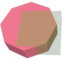
Returns that part of geom1 that is not part of geom2.
Availability: 2.2.0
 This
method needs SFCGAL backend.
This
method needs SFCGAL backend.
This
method implements the SQL/MM specification.
SQL-MM IEC 13249-3: 5.1
This
function supports 3d and will not drop the z-index.
This
function supports Polyhedral surfaces.
This
function supports Triangles and Triangulated Irregular Network Surfaces
(TIN).
Examples
3D images were generated using PostGIS ST_AsX3D and rendering in HTML using X3Dom HTML Javascript rendering library.
Original 3D geometries overlaid. geom2 is the part that will be removed. |
What’s left after removing geom2 |