PostGIS
Synopsis
+geometry +ST_LineInterpolatePoints(+`geometry
`+a_linestring, float8 a_fraction, boolean repeat`)`;
Description
Returns one or more points interpolated along a line at a fractional interval. The first argument must be a LINESTRING. The second argument is a float8 between 0 and 1 representing the spacing between the points as a fraction of line length. If the third argument is false, at most one point will be constructed (which is equivalent to ST_LineInterpolatePoint.)
If the result has zero or one points, it is returned as a POINT. If it has two or more points, it is returned as a MULTIPOINT.
Availability: 2.5.0
 This function
supports 3d and will not drop the z-index.
 This function
supports M coordinates.
Examples

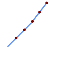
A LineString with points interpolated every 20%
--Return points each 20% along a 2D line
SELECT ST_AsText(ST_LineInterpolatePoints('LINESTRING(25 50, 100 125, 150 190)', 0.20))
----------------
 MULTIPOINT((51.5974135047432 76.5974135047432),(78.1948270094864 103.194827009486),(104.132163186446 130.37181214238),(127.066081593223 160.18590607119),(150 190))