PostGIS
Description
A set-returning function (SRF) that extracts the coordinates (vertices)
of a geometry. It returns a set of
geometry_dump rows, each containing a geometry
(`geom field) and an array of integers (path` field).
-
the `geom` field `POINT`s represent the coordinates of the supplied geometry.
-
the `path
field (an `integer[]) is an index enumerating the coordinate positions in the elements of the supplied geometry. The indices are 1-based. For example, for aLINESTRINGthe paths are{i}whereiis thenthcoordinate in theLINESTRING. For aPOLYGONthe paths are{i,j}whereiis the ring number (1 is outer; inner rings follow) andjis the coordinate position in the ring.
To obtain a single geometry containing the coordinates use ST_Points.
Enhanced: 2.1.0 Faster speed. Reimplemented as native-C.
Enhanced: 2.0.0 support for Polyhedral surfaces, Triangles and TIN was introduced.
Availability: 1.5.0
 This method
supports Circular Strings and Curves
 This function
supports Polyhedral surfaces.
 This function
supports Triangles and Triangulated Irregular Network Surfaces (TIN).
 This function
supports 3d and will not drop the z-index.
Classic Explode a Table of LineStrings into nodes
SELECT edge_id, (dp).path[1] As index, ST_AsText((dp).geom) As wktnode
FROM (SELECT 1 As edge_id
    , ST_DumpPoints(ST_GeomFromText('LINESTRING(1 2, 3 4, 10 10)')) AS dp
     UNION ALL
     SELECT 2 As edge_id
    , ST_DumpPoints(ST_GeomFromText('LINESTRING(3 5, 5 6, 9 10)')) AS dp
   ) As foo;
 edge_id | index |    wktnode
---------+-------+--------------
       1 |     1 | POINT(1 2)
       1 |     2 | POINT(3 4)
       1 |     3 | POINT(10 10)
       2 |     1 | POINT(3 5)
       2 |     2 | POINT(5 6)
       2 |     3 | POINT(9 10)
Standard Geometry Examples

SELECT path, ST_AsText(geom)
FROM (
  SELECT (ST_DumpPoints(g.geom)).*
  FROM
    (SELECT
       'GEOMETRYCOLLECTION(
          POINT ( 0 1 ),
          LINESTRING ( 0 3, 3 4 ),
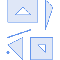
          POLYGON (( 2 0, 2 3, 0 2, 2 0 )),
          POLYGON (( 3 0, 3 3, 6 3, 6 0, 3 0 ),
                   ( 5 1, 4 2, 5 2, 5 1 )),
          MULTIPOLYGON (
                  (( 0 5, 0 8, 4 8, 4 5, 0 5 ),
                   ( 1 6, 3 6, 2 7, 1 6 )),
                  (( 5 4, 5 8, 6 7, 5 4 ))
          )
        )'::geometry AS geom
    ) AS g
  ) j;

   path    | st_astext
-----------+------------
 {1,1}     | POINT(0 1)
 {2,1}     | POINT(0 3)
 {2,2}     | POINT(3 4)
 {3,1,1}   | POINT(2 0)
 {3,1,2}   | POINT(2 3)
 {3,1,3}   | POINT(0 2)
 {3,1,4}   | POINT(2 0)
 {4,1,1}   | POINT(3 0)
 {4,1,2}   | POINT(3 3)
 {4,1,3}   | POINT(6 3)
 {4,1,4}   | POINT(6 0)
 {4,1,5}   | POINT(3 0)
 {4,2,1}   | POINT(5 1)
 {4,2,2}   | POINT(4 2)
 {4,2,3}   | POINT(5 2)
 {4,2,4}   | POINT(5 1)
 {5,1,1,1} | POINT(0 5)
 {5,1,1,2} | POINT(0 8)
 {5,1,1,3} | POINT(4 8)
 {5,1,1,4} | POINT(4 5)
 {5,1,1,5} | POINT(0 5)
 {5,1,2,1} | POINT(1 6)
 {5,1,2,2} | POINT(3 6)
 {5,1,2,3} | POINT(2 7)
 {5,1,2,4} | POINT(1 6)
 {5,2,1,1} | POINT(5 4)
 {5,2,1,2} | POINT(5 8)
 {5,2,1,3} | POINT(6 7)
 {5,2,1,4} | POINT(5 4)
(29 rows)
Polyhedral Surfaces, TIN and Triangle Examples
-- Polyhedral surface cube --
SELECT (g.gdump).path, ST_AsEWKT((g.gdump).geom) as wkt
  FROM
    (SELECT
       ST_DumpPoints(ST_GeomFromEWKT('POLYHEDRALSURFACE( ((0 0 0, 0 0 1, 0 1 1, 0 1 0, 0 0 0)),
((0 0 0, 0 1 0, 1 1 0, 1 0 0, 0 0 0)), ((0 0 0, 1 0 0, 1 0 1, 0 0 1, 0 0 0)),
((1 1 0, 1 1 1, 1 0 1, 1 0 0, 1 1 0)),
((0 1 0, 0 1 1, 1 1 1, 1 1 0, 0 1 0)), ((0 0 1, 1 0 1, 1 1 1, 0 1 1, 0 0 1)) )') ) AS gdump
    ) AS g;
-- result --
  path   |     wkt
---------+--------------
 {1,1,1} | POINT(0 0 0)
 {1,1,2} | POINT(0 0 1)
 {1,1,3} | POINT(0 1 1)
 {1,1,4} | POINT(0 1 0)
 {1,1,5} | POINT(0 0 0)
 {2,1,1} | POINT(0 0 0)
 {2,1,2} | POINT(0 1 0)
 {2,1,3} | POINT(1 1 0)
 {2,1,4} | POINT(1 0 0)
 {2,1,5} | POINT(0 0 0)
 {3,1,1} | POINT(0 0 0)
 {3,1,2} | POINT(1 0 0)
 {3,1,3} | POINT(1 0 1)
 {3,1,4} | POINT(0 0 1)
 {3,1,5} | POINT(0 0 0)
 {4,1,1} | POINT(1 1 0)
 {4,1,2} | POINT(1 1 1)
 {4,1,3} | POINT(1 0 1)
 {4,1,4} | POINT(1 0 0)
 {4,1,5} | POINT(1 1 0)
 {5,1,1} | POINT(0 1 0)
 {5,1,2} | POINT(0 1 1)
 {5,1,3} | POINT(1 1 1)
 {5,1,4} | POINT(1 1 0)
 {5,1,5} | POINT(0 1 0)
 {6,1,1} | POINT(0 0 1)
 {6,1,2} | POINT(1 0 1)
 {6,1,3} | POINT(1 1 1)
 {6,1,4} | POINT(0 1 1)
 {6,1,5} | POINT(0 0 1)
(30 rows)
-- Triangle --
SELECT (g.gdump).path, ST_AsText((g.gdump).geom) as wkt
FROM
(SELECT
ST_DumpPoints( ST_GeomFromEWKT('TRIANGLE ((
0 0,
0 9,
9 0,
0 0
))') ) AS gdump
) AS g;
-- result --
path | wkt
------+------------
{1} | POINT(0 0)
{2} | POINT(0 9)
{3} | POINT(9 0)
{4} | POINT(0 0)-- TIN --
SELECT (g.gdump).path, ST_AsEWKT((g.gdump).geom) as wkt
FROM
(SELECT
ST_DumpPoints( ST_GeomFromEWKT('TIN (((
0 0 0,
0 0 1,
0 1 0,
0 0 0
)), ((
0 0 0,
0 1 0,
1 1 0,
0 0 0
))
)') ) AS gdump
) AS g;
-- result --
path | wkt
---------+--------------
{1,1,1} | POINT(0 0 0)
{1,1,2} | POINT(0 0 1)
{1,1,3} | POINT(0 1 0)
{1,1,4} | POINT(0 0 0)
{2,1,1} | POINT(0 0 0)
{2,1,2} | POINT(0 1 0)
{2,1,3} | POINT(1 1 0)
{2,1,4} | POINT(0 0 0)
(8 rows)See Also
geometry_dump, Section 15.6, “PostGIS Geometry / Geography / Raster Dump Functions”, ST_Dump, ST_DumpRings, ST_Points
ST_Dump |
ST_DumpSegments |