PostGIS
Name
ST_ClosestPoint — Returns the 2D point on g1 that is closest to g2. This is the first point of the shortest line from one geometry to the other.
Description
Returns the 2-dimensional point on geom1 that is closest to
geom2. This is the first point of the shortest line between the
geometries (as computed by ST_ShortestLine).
|
Availability: 1.5.0
Examples

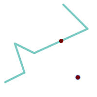
The closest point for a Point and a LineString is the point itself. The closest point for a LineString and a Point is a point on the line.
SELECT ST_AsText( ST_ClosestPoint(pt,line)) AS cp_pt_line,
       ST_AsText( ST_ClosestPoint(line,pt)) AS cp_line_pt
    FROM (SELECT 'POINT (160 40)'::geometry AS pt,
                 'LINESTRING (10 30, 50 50, 30 110, 70 90, 180 140, 130 190)'::geometry AS line ) AS t;

   cp_pt_line   |                cp_line_pt
----------------+------------------------------------------
 POINT(160 40)  | POINT(125.75342465753425 115.34246575342466)
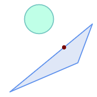
The closest point on polygon A to polygon B
SELECT ST_AsText( ST_ClosestPoint(
        'POLYGON ((190 150, 20 10, 160 70, 190 150))',
        ST_Buffer('POINT(80 160)', 30)  )) As ptwkt;
------------------------------------------
 POINT(131.59149149528952 101.89887534906197)