PostGIS
Description
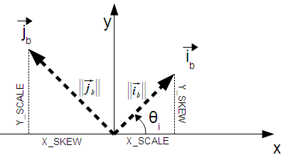
Returns the width of a pixel in geometric units of the spatial reference system. In the common case where there is no skew, the pixel width is just the scale ratio between geometric coordinates and raster pixels.
The following diagram demonstrates the relationship:

Pixel Width: Pixel size in the i direction
Pixel Height: Pixel size in the j direction
Examples: Rasters with no skew
SELECT ST_Width(rast) As rastwidth, ST_PixelWidth(rast) As pixwidth,
    ST_ScaleX(rast) As scalex, ST_ScaleY(rast) As scaley, ST_SkewX(rast) As skewx,
    ST_SkewY(rast) As skewy
    FROM dummy_rast;

    rastwidth | pixwidth | scalex | scaley | skewx | skewy
    -----------+----------+--------+--------+-------+----------
    10 |        2 |      2 |      3 |     0 |        0
     5 |     0.05 |   0.05 |  -0.05 |     0 |        0
Examples: Rasters with skew different than 0
SELECT ST_Width(rast) As rastwidth, ST_PixelWidth(rast) As pixwidth,
    ST_ScaleX(rast) As scalex, ST_ScaleY(rast) As scaley, ST_SkewX(rast) As skewx,
    ST_SkewY(rast) As skewy
    FROM (SELECT ST_SetSkew(rast,0.5,0.5) As rast
    FROM dummy_rast) As skewed;

    rastwidth |     pixwidth      | scalex | scaley | skewx | skewy
    -----------+-------------------+--------+--------+-------+----------
    10 |  2.06155281280883 |      2 |      3 |   0.5 |      0.5
     5 | 0.502493781056044 |   0.05 |  -0.05 |   0.5 |      0.5