PostGIS
Name
ST_InvDistWeight4ma — Raster processing function that interpolates a pixel’s value from the pixel’s neighborhood.
Synopsis
+double precision +ST_InvDistWeight4ma(+`double
precision[][][] `+value, integer[][] pos, text[]
VARIADIC userargs`)`;
Description
Calculate an interpolated value for a pixel using the Inverse Distance Weighted method.
There are two optional parameters that can be passed through
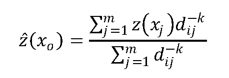
userargs. The first parameter is the power factor (variable k in the
equation below) between 0 and 1 used in the Inverse Distance Weighted
equation. If not specified, default value is 1. The second parameter is
the weight percentage applied only when the value of the pixel of
interest is included with the interpolated value from the neighborhood.
If not specified and the pixel of interest has a value, that value is
returned.
The basic inverse distance weight equation is:

k = power factor, a real number between 0 and 1
|
Availability: 2.1.0
